You are here

Visualization

9 Maps that Illustrate the Struggles of the South


Source: USDA

huffingtonpost.com - by Emily Cohn - March 6, 2014

Look, there are lots of things to love about the South. It's clean and quiet. There's delicious food, good people and often amazing weather. But that's exactly why it makes us so sad to think about all the ways in which the region is struggling today.

First off, poverty rates are a lot higher in the South.

(READ COMPLETE ARTICLE)

Country / Region Tags: 
Problem, Solution, SitRep, or ?: 

Webinar - National Resilience Dashboard Task Force Initiative

February 11, 2014

CLICK HERE - Webinar and Slideshow - National Resilience Dashboard Task Force Initiative

(FOR SLIDESHOW ONLY, CLICK ON THE ATTACHMENT BELOW)

Country / Region Tags: 
General Topic Tags: 
Problem, Solution, SitRep, or ?: 

A Picture of Detroit Ruin, Street by Forlorn Street


Leonard Patterson took a picture of a parcel of land on Detroit’s northwest side earlier this month as part of an emerging database. Credit Fabrizio Costantini for The New York Times

nytimes.com - by Monica Davey - February 17, 2014

DETROIT — A midnight blue Chevy rolls slowly down a snow-covered street, an emergency strobe light on its roof and a sign on its side that promises this is “official business.” At each house, business, even vacant lot, workers in the car pause to decide whether someone lives there and what shape the place is in before snapping a photo and beaming it to “mission control” miles away.

All over Detroit, scores of these workers — on some days as many as 75 three-person teams — have been wending their way through the streets since December, cataloging on computer tablets one of this bankrupt city’s most devastating ailments: its tens of thousands of abandoned and dilapidated buildings.

(READ COMPLETE ARTICLE)

Country / Region Tags: 
General Topic Tags: 
Problem, Solution, SitRep, or ?: 

Fed Flood Maps Left NY Unprepared for Sandy — and FEMA Knew It

Flooding in Red Hook, Brooklyn after Sandy (Flickr/gunnicool)

The agency ignored state and city officials' appeals to update the maps with better data until it was too late.

wnyc.org - December 6, 2013
by Al Shaw : ProPublica / Theodoric Meyer : ProPublica / Christie Thompson : ProPublica

When Patrice and Philip Morgan bought a house near the ocean in Brooklyn, they were not particularly worried about the threat of flooding.

Federal maps showed their home was outside the area at a high risk of flood damage. . .

. . . But the maps drawn up by the Federal Emergency Management Agency were wrong. And government officials knew it.

(READ COMPLETE ARTICLE)

Country / Region Tags: 
Problem, Solution, SitRep, or ?: 

Fracking Across the United States


View Fraccidents Map in a larger map

Image: A map of fracking accidents in the United States

earthjustice.org

The country is in the midst of an unprecedented oil and gas drilling rush—brought on by a controversial technology called hydraulic fracturing or fracking. Along with this fracking-enabled oil and gas rush have come troubling reports of poisoned drinking water, polluted air, mysterious animal deaths, industrial disasters and explosions. We call them Fraccidents.

(VIEW WEBSITE)

Country / Region Tags: 
Problem, Solution, SitRep, or ?: 

These are the Humanitarian Decision Makers

submitted by Albert Gomez


veritythink.com - by Andrej Verity - September 3, 2013

In my June post Who are the Humanitarian Decision Makers, I outlined why I have problems with how easily we use the phrase “for the decision makers” without really knowing who they are. Once you start investigating the problem, you quickly realize how large and diverse the range of decision makers are in humanitarian response.

Now, it is easy to complain but harder to do something. So rather than leaving this problem to fester within the community, a few of us decided to do something.

(READ COMPLETE ARTICLE)

Country / Region Tags: 
Problem, Solution, SitRep, or ?: 

Mozilla Ignite Challenge - Real-Time Emergency Response

                                                   (CLICK ON IMAGE BELOW TO ENLARGE)


mozillaignite.org - March 31, 2013

Mozilla Ignite is an open innovation challenge hosted by Mozilla and the National Science Foundation as part of the US Ignite initiative. The goal: imagine and build apps that show the full potential of next-generation networks, in areas that matter -- like healthcare, education, energy, manufacturing and public safety.

Real-Time Emergency Response - What problem are you intending to solve?

Detection, observation, and assessment of situations requiring intervention by emergency responders depends on high-quality "live" data.

(READ COMPLETE ARTICLE)

Country / Region Tags: 
Problem, Solution, SitRep, or ?: 

Geofeedia - Pioneering Location-Based Social Media Monitoring

geofeedia.com

Location-based streaming, search, monitoring, and analytics.

Create live, location-based social media streams, or “Geofeeds”. Once you create a Geofeed – by simply entering an address or drawing a boundary around a location on a map – you can search, monitor and analyze all social media activity from that location.

http://corp.geofeedia.com/company/how-it-works/

Country / Region Tags: 
Problem, Solution, SitRep, or ?: 

Probability Maps Help Detect Food Contamination

Sandia's stochastic network metholodogy accelerates spread of food-borne illness // Source: sandia.gov

submitted by Luis Kun

Homeland Security News Wire - October 1, 2012

Researchers demonstrate how developing a probability map of the food supply network using stochastic network representation might shorten the time it takes to track down contaminated food sources; stochastic mapping shows what is known about how product flows through the distribution supply chain and provides a means to express all the uncertainties in potential supplier-customer relationships that persist due to incomplete information

Uncovering the sources of fresh food contamination could become faster and easier thanks to analysis done at Sandia National Laboratories’ National Infrastructure Simulation and Analysis Center (NISAC).

Country / Region Tags: 
General Topic Tags: 
Problem, Solution, SitRep, or ?: 

Researchers Use GPS Data to Speed Up Tsunami Warnings


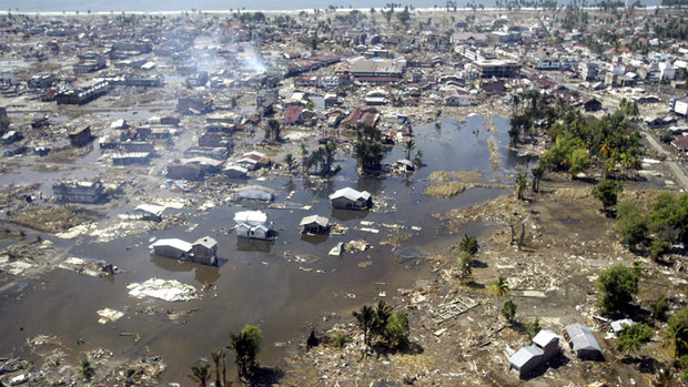
In this Jan. 2, 2005 file photo, a wide area of destruction is shown from an aerial view taken over Meulaboh, 250 kilometers (156 Miles) west of Banda Aceh, Indonesia. Researchers in the United States are hoping to use GPS data to speed up current warnings. (AP Photo/Dita Alangkara, File)

U.S. seismologists currently testing new warning system

by Andrew Pinsent - CBC News - May 5, 2012

Scientists in the United States have been testing an advanced tsunami warning system using GPS data, combined with traditional seismology networks, to attempt to detect the magnitude of an earthquake faster so warnings of potential tsunamis can get out to potentially affected areas sooner.

The prototype is called California Integrated Seismic Network (CISN), and is a collaboration between the United States Geological Survey (USGS) and The Gordon and Betty Moore Foundation, whose focus is on environmental conservation.

Country / Region Tags: 
Problem, Solution, SitRep, or ?: 

Pages

Subscribe to Visualization
howdy folks