Geospatial Intelligence and Visual Analytics

Primary tabs

The Geospatial Intelligence and Visual Analytics working group is focused on advances in geospatial intelligence and visual analytics.

The mission of the Geospatial Intelligence and Visual Analytics working group is to focus on how advances in geospatial intelligence and visual analytics are shaping how intelligent social networks collectively address risk, vulnerability, and resilience.

Members

bevcorwin Craig Vanderwagen drvroeg efrost Eric Kutner George Bressler
Jeff Kutner Kathy Gilbeaux Katie Rast Laurie Van Leuven Maeryn Obley mdmcdonald
Michael Gresalfi

Email address for group

geospatial-intelligence-and-visual-analytics@m.resiliencesystem.org

These Interactive Maps Compare 19th Century American Cities to Today

As mind-blowing as science is these days, it's probably safe to say that we're not going to invent a time machine within the next century. Through the magic of code, though, there is an entertaining alternative in the world of interactive maps. Obviously, The Smithsonian is on it.

The magazine recently dipped into David Rumsey's collection of over 150,000 maps to find some of the best representations of American cities over the past couple hundred years. With some simple programming, they were able to overlay images of vintage maps of some major cities onto satellite images from today. The results are fascinating.

See maps of New York City, Denver, Los Angeles, San Francisco, Denver, and Washington, DC

Country / Region Tags: 
General Topic Tags: 
Problem, Solution, SitRep, or ?: 

Map Mashes Hurricane Information with Energy Infrastructure Data

                                  (FOR THE INTERACTIVE MAP - CLICK ON MAP IMAGE BELOW)


emergencymgmt.com - by Sarah Rich - July 11, 2013

This year's hurricane season may prove a bit different for the energy sector, thanks to a newly updated interactive map, pictured (above), made available by the U.S. Energy Information Administration (EIA).

What was an existing state map launched by the agency last September now includes more than 20 layers of GIS data to plot the nation’s energy infrastructure and resources. The data can be mashed up with real-time tropical storm and hurricane information from the National Hurricane Center, so resources like offshore production rigs, pipelines, coastal refineries power plants, and energy import and exports sites can be monitored as the severe weather occurs, according to the EIA.

(READ COMPLETE ARTICLE)

Geofeedia - Pioneering Location-Based Social Media Monitoring

geofeedia.com

Location-based streaming, search, monitoring, and analytics.

Create live, location-based social media streams, or “Geofeeds”. Once you create a Geofeed – by simply entering an address or drawing a boundary around a location on a map – you can search, monitor and analyze all social media activity from that location.

http://corp.geofeedia.com/company/how-it-works/

Country / Region Tags: 
Problem, Solution, SitRep, or ?: 

Lessons Learned Regarding the Use of Spatial Data and Geographic Information Systems (GIS) During Hurricane Floyd

submitted by Karen Becker

erh.noaa.gov

Executive Summary

Hurricane Floyd, which made landfall along the North Carolina coast on September 15, 1999, was a
devastating and tragic event. The massive size and strength of the storm, combined with significant
rainfall, caused federal, state, and local emergency management personnel along the entire east coast of
the United States to prepare, respond, and, if necessary, recover from the effects of Hurricane Floyd. The
response and recovery activities associated with the storm highlight how advances in technology have
enhanced the ability to deal with disasters.

Is it time to get your flu shot?

Estimates were made using a model that proved accurate when compared to historic official flu activity data.

google.org - Flu Trends

We've found that certain search terms are good indicators of flu activity. Google Flu Trends uses aggregated Google search data to estimate flu activity.

(EXPLORE FLU TRENDS)

Localizing Kickstarter: Mapping Mashup Helps Keep Cash Close to Home

submitted by Albert Gomez

good.is - by Zak Stone - September 11, 2012

How do you decide which creative projects to back on crowdfunding platforms like Kickstarter?

If you're inclined to think local, you're not alone, according to Justin Wilcox, a software developer who interviewed Kickstarter backers to gain insight into their perferences. . .
. . . "Kickstarter has some rudimentary capabilities to find projects around you"—like searching by city—"but we saw a need, an interest, to develop that to much more depth.”

(READ COMPLETE ARTICLE)

Nokia Knows Where You'll Be 24 Hours From Now

wirelessdesignmag.com - businessinsider.com
- by Geoffrey Ingersoll - August 13, 2012

Not only does your phone know where you are, but it knows where you are going to be. It may even know why you're going there.

He calls it the "Interdependence and Predictability of Human Mobility and Social Interactions," but the algorithm researcher Mirco Musolesi and his team recently tested in the UK stirs up thoughts reminiscent of Phillip K. Dick's Minority Report, and all the moral trappings that come with it.

(READ COMPLETE ARTICLE)

Mirco Musolesi - Interdependence and Predictability of Human Mobility and Social Interactions (6 page .PDF file)
http://www.cs.bham.ac.uk/~musolesm/papers/mdc12.pdf

How Crisis Mapping Saved Lives in Haiti

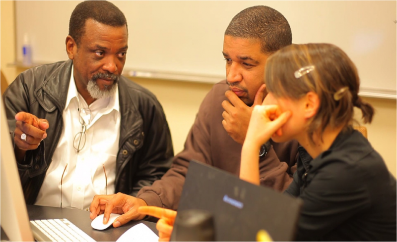
Haitian volunteers crisis mapping Haiti with Sabina Carlson in the Haiti Situation Room at The Fletcher School. Sabina, who speak fluent Creole, was the project's volunteer liaison for the Haitian Diaspora. Credit: Ushahidi.

submitted by Albert Gomez

Image: Haitian volunteers crisis mapping Haiti with Sabina Carlson in the Haiti Situation Room at The Fletcher School. Sabina, who speak fluent Creole, was the project's volunteer liaison for the Haitian Diaspora. Credit: Ushahidi.

nationalgeographic.com - Patrick Meier - July 2nd, 2012

The National Geographic Society has a long history of crisis mapping disasters. But what happened in Haiti on January 12, 2010 would forever change the very concept of a crisis map. A devastating earthquake struck the country’s capital that Tuesday afternoon.

(VIEW COMPLETE ARTICLE)
 

Researchers Use GPS Data to Speed Up Tsunami Warnings


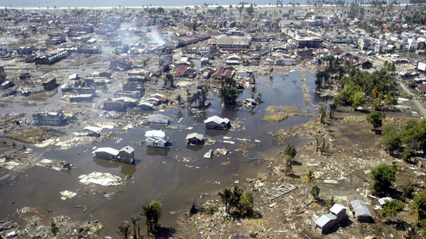
In this Jan. 2, 2005 file photo, a wide area of destruction is shown from an aerial view taken over Meulaboh, 250 kilometers (156 Miles) west of Banda Aceh, Indonesia. Researchers in the United States are hoping to use GPS data to speed up current warnings. (AP Photo/Dita Alangkara, File)

U.S. seismologists currently testing new warning system

by Andrew Pinsent - CBC News - May 5, 2012

Scientists in the United States have been testing an advanced tsunami warning system using GPS data, combined with traditional seismology networks, to attempt to detect the magnitude of an earthquake faster so warnings of potential tsunamis can get out to potentially affected areas sooner.

The prototype is called California Integrated Seismic Network (CISN), and is a collaboration between the United States Geological Survey (USGS) and The Gordon and Betty Moore Foundation, whose focus is on environmental conservation.

Country / Region Tags: 
Problem, Solution, SitRep, or ?: 

Volunteers Creating Change: 6th Annual Disaster Volunteer Conference - May 1, 2012

On Tuesday, May 1, at  one of New York City's premier auditoriums, Pace University's Michael Schimmel Center for the Arts in lower Manhattan, the NYC Citizen Corps Council will be hosting the 6th annual Disaster Volunteer Conference, Volunteers Creating Change.  Enjoy the exhibits, dinner provided by The Salvation Army Greater New York Division, and an educational conference with fellow volunteers.  The conference’s distinguished speakers will include a welcome address by Joseph F. Bruno (Commissioner – NYC Office of Emergency Management), a keynote address by Jeff Parness (Founder and Executive Director – New York Says Thank You Foundation), followed by a panel discussion moderated by Herman Schaffer, MSW (Director, Community Outreach – NYC Office of Emergency Management) with a growing list of panelists, including Gary Bagley (Executive Director – New York Cares) and Sara Farmer (Data Humanitarian – Standy-by Task force, Crisismappers Network, and Ushahidi Community).  For additional information and to register, visit www.NYC.gov/citizencorps.

Pages

howdy folks
Page loaded in 0.705 seconds.