Geospatial Intelligence and Visual Analytics

Primary tabs

The Geospatial Intelligence and Visual Analytics working group is focused on advances in geospatial intelligence and visual analytics.

The mission of the Geospatial Intelligence and Visual Analytics working group is to focus on how advances in geospatial intelligence and visual analytics are shaping how intelligent social networks collectively address risk, vulnerability, and resilience.

Members

bevcorwin Craig Vanderwagen drvroeg efrost Eric Kutner George Bressler
Jeff Kutner Kathy Gilbeaux Katie Rast Laurie Van Leuven Maeryn Obley mdmcdonald
Michael Gresalfi

Email address for group

geospatial-intelligence-and-visual-analytics@m.resiliencesystem.org

Future Trends in Geospatial Information Management: The Five to Ten Year Vision

submitted by Samuel Bendett

United Nations Initiative on Global Geospatial Information Management - April 24, 2012

A working group was established to assess the future trends in geospatial information management at the 1st meeting of the UN Committee on GGIM in Seoul, Korea. Chaired by Dr. Vanessa Lawrence, Director General and Chief Executive of Ordnance Survey, the working group has received written inputs from 29 persons or institutions. A summary of the future trends shall be presented during this forum in Amsterdam, followed by discussion among all the participants. Meanwhile, the process of soliciting views on future trends continue and the working group welcomes any additional inputs. A consolidated paper on the future trends shall be discussed in the 2nd Session of the Committee of Experts on Global Geospatial Information Management.

http://ggim.un.org/

Background paper:
Future trends in geospatial information management: the five to ten year vision (8 page .PDF file)


Country / Region Tags: 
General Topic Tags: 
Problem, Solution, SitRep, or ?: 

Looking Back on the Limits of Growth


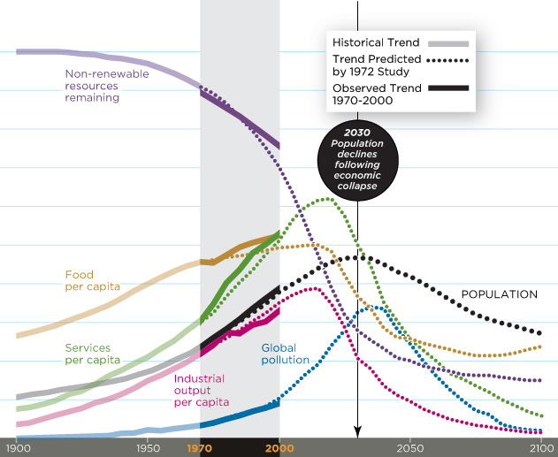
Chart Sources: Meadows, D.H., Meadows, D.L., Randers, J. and Behrens III, W.W. (1972) /  Linda Eckstein

by Mark Strauss - Smithsonian Magazine - April 2012

Recent research supports the conclusions of a controversial environmental study released 40 years ago: The world is on track for disaster. So says Australian physicist Graham Turner, who revisited perhaps the most groundbreaking academic work of the 1970s,The Limits to Growth.

Written by MIT researchers for an international think tank, the Club of Rome, the study used computers to model several possible future scenarios. The business-as-usual scenario estimated that if human beings continued to consume more than nature was capable of providing, global economic collapse and precipitous population decline could occur by 2030.

(GO TO THE SMITHSONIAN MAGAZINE ARTICLE)

Limits to Growth: The 30-Year Update

The Club of Rome

Country / Region Tags: 
Problem, Solution, SitRep, or ?: 

BioSense Program Redesign


The BioSense Program provides local, state, and federal partners a timely regional and national picture of trends in disease syndromes and situation awareness. BioSense is in the midst of a redesign that shifts the program's focus to meet the needs of stakeholders and end users in state and local health departments, CDC programs, hospitals, and other federal programs (i.e. DoD and VA) to improve regional and national coverage.

https://sites.google.com/site/biosenseredesign/about

At a recent Forum hosted by the Office of the Assistant Secretary for Preparedness and Response (ASPR), state and local health practitioners expressed their desire to more easily access social media data. The Now Trending Challenge was created to help fill this need.

Honest Buildings

submitted by Albert Gomez

Honest Buildings has created a profile for any building in the world with an address. This platform is the first place that connects occupants, service providers and owners to each other and the buildings where they live, work and spend their time. Type in an address, and the free service instantly finds information about any commercial or residential building in the U.S., including pictures, reviews, Honesty Ratings(TM), open and completed projects, and the people associated with that building, including service providers, managers and owners.

Anyone can use Honest Buildings to compare buildings based on size, location, type, Honesty Ratings, associated organizations, and the types of projects that have been completed, helping them to make better-informed decisions about real estate.

Projects can range from a new bathroom renovation to obtaining LEED certification for a new real estate development, and everything in between. During its private beta, Honest Buildings has already amassed over 50,000 projects representing over 10 billion square feet of buildings.

Infrastructure Security, Disaster Planning “Super Map” Developed

submitted by Samuel Bendett


I-COP stacks multiple flows of information into a single picture // Source: ac.jp

Homeland Security News Wire - March 7, 2012

A U.S. Marine stationed at the Quantico base in Virginia has developed sophisticated mapping software that can give users full situational awareness of their surroundings in real-time.

The Installation Common Operational Picture (I-COP), developed by Marine specialist Michael Lisovich, is essentially a “super map,” taking in a torrent of data streams from emergency dispatch reports to weather forecasts, traffic reports, and security system alerts.

Pete Streng, Quantico’s director of operations, said the tool, which is accessible online, essentially provides users with up to the minute information on everything around the base, allowing officials to make fast, informed decisions.

InsideNovareports that Streng contacted Lisovich several years ago requesting a system that would give officials a better grasp of the base’s critical infrastructure system.

Transforming Earthquake Detection?

submitted by Linton Wells

sciencemag.org - January 20, 2012

Earthquakes are a collective experience. Citizens have long participated in earthquake science through the reporting, collection, and analysis of individual experiences. The value of citizen-generated status reports was clear after the 1995 Kobe, Japan, earthquake (1). Today's communications infrastructure has taken citizen engagement to a new level: Earthquake-related Twitter messages can outrun the shaking (2), Internet traffic detects earthquakes (37) and maps the distribution of shaking in minutes (810), and accelerometers in consumer electronic devices record seismic waveforms (1116). What are we learning from this flood of data, and what are the limitations? How do we harness these new capabilities for scientific discovery, and what is the role of education?

(GO TO THE COMPLETE ARTICLE)

Country / Region Tags: 
General Topic Tags: 
Problem, Solution, SitRep, or ?: 

Rapid Appraisal Methods

usaid.gov

WHAT IS RAPID APPRAISAL?

Rapid Appraisal (RA) is an approach that draws on multiple evaluation methods and techniques to quickly, yet systematically, collect data when time in the field is limited. RA practices are also useful when there are budget constraints or limited availability of reliable secondary data. For example, time and budget limitations may preclude the option of using representative sample surveys.

BENEFITS – WHEN TO USE RAPID APPRAISAL METHODS

Rapid appraisals are quick and can be done at relatively low cost. Rapid appraisal methods can help gather, analyze, and report relevant information for decision-makers within days or weeks. This is not possible with sample surveys. RAs can be used in the following cases:

  • for formative evaluations, to make mid-course corrections in project design or implementation when customer or partner feedback indicates a problem (See ADS 203.3.6.1);

  • when a key management decision is required and there is inadequate information;

  • for performance monitoring, when data are collected and the techniques are repeated over time for measurement purposes;

  • to better understand the issues behind performance monitoring data; and

  • for project pre-design assessment.

The Age of Big Data

Image/Chad Hagen - The New York Times Company

submitted by Samuel Bendett

by Steve Lohr - The New York Times -February 11, 2012

GOOD with numbers? Fascinated by data? The sound you hear is opportunity knocking.

Mo Zhou was snapped up by I.B.M. last summer, as a freshly minted Yale M.B.A., to join the technology company’s fast-growing ranks of data consultants. They help businesses make sense of an explosion of data — Web traffic and social network comments, as well as software and sensors that monitor shipments, suppliers and customers — to guide decisions, trim costs and lift sales. “I’ve always had a love of numbers,” says Ms. Zhou, whose job as a data analyst suits her skills.

(READ COMPLETE ARTICLE)

X24 - Mexico - Exercise 24

VizCenter - San Diego State University

February 8, 2012 - 8:00am

Purpose of X24 México

Exercise 24 (X24) México is the third iteration of a primarily virtual, open-invitation, humanitarian assistance and disaster relief (HADR) exercise with real-world functional components that is hosted by San Diego State University’s “Immersive Visualization Center” (VizCenter).

Participants include DHS/Office of Health Affairs, NORAD-NORTHCOM, US Customs and Border Protection/Global Borders College, Mexican Army and Navy, Mexico Federal Police, Ministry of Defense from Vietnam, India National Disaster Management Agency, World Shipping Council, Red Cross, Pacific Disaster Center, NYK Logistics, National defense University, and growing.

X24 México Goals

Country / Region Tags: 
Problem, Solution, SitRep, or ?: 

Pages

howdy folks
Page loaded in 0.668 seconds.