You are here

Disaster Management

Primary tabs

This working group is focused on discussions about disaster management.

The mission of this working group is to focus on discussions about disaster management.

Members

Kathy Gilbeaux Maeryn Obley mdmcdonald

Email address for group

disaster-management@m.resiliencesystem.org

Predicting Locations of Emergency & Damage During Disaster Using VGI Data

submitted by Alister Wm Macintyre

                                                     (CLICK ON IMAGE BELOW - TO ENLARGE)


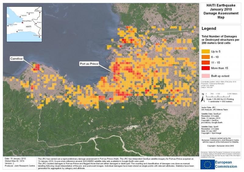
ushahidi.com - by Prateek Budhwar

The VGI data obtained from the Ushahidi-Haiti platform during the first 72 hours of Earthquake in Haiti can be used for predicting the locations of ‘Emergency and damaged areas’ using Ushahidi Reports in Port-au-Prince. Two rapid and very successful VGI deployments helped coordinate disaster response after a devastating magnitude 7 earthquake struck Haiti in January 2010.

OpenStreetMap (OSM) project volunteers working outside Haiti created a digital street map of Port-au-Prince and other places in Haiti very rapidly using fine-resolution imagery to trace vector maps of streets and other features.

(READ COMPLETE ARTICLE)

Country / Region Tags: 
Problem, Solution, SitRep, or ?: 

Mexico Quake Tweet Volume and Characteristics

submitted by Samuel Bendett

Sender: crisismappers
Date: Tue, 20 Mar 2012 13:55:14 -0700
To: <crisismappers>
ReplyTo: crisismappers
Subject: [CrisisMappers] Mexico quake tweet volume and characteristics
Some relatively random data points...

We've saw about 10,000 English tweets in the first hour and 23,000 in the second. Third hour is down, will be about half the rate of the second hour if sustained.

Recurring themes include words like rattle, suffer, long slow roller, hard, saddened, worried, awful, hate, bad.

I'm seeing a fair bit of "help us report" tweets, which is coming from a tweet that said "earthquake preparedness helps us report none to minor damage and no victims so far," from Mexico City.

English-language tweets from Mexico are making up 8 percent of the total. 55 percent are from the U.S.

Spanish tweets - 488 in the first hour, 1,400 in the second and current rate will product about 1,000 in the third hour.

Most common words in the Spanish tweets are disfrutar and malo.

Spanish tweets are coming almost 50/50 from Mexico and the U.S.

Almost 75 percent of the Spanish tweets were from men, v. a close to 50/50 split for English.

Country / Region Tags: 
Problem, Solution, SitRep, or ?: 

Researchers Developing Wireless Emergency Network for Disasters

submitted by Samuel Bendett

Homeland Security News Wire - March 16, 2012

University of Arkansas researchers are developing a solar powered wireless emergency communications network that can be deployed during major disasters to transmit critical warnings and geographic information.

The network, which researchers call an emergency “mesh,” is entirely self-sustainable so even when power and the Internet has been knocked out, residents affected by a disaster can still receive information on their computers, smartphones, and other digital devices.

“Deployment of this system could warn people to get out of harm’s way and could help emergency services personnel reach victims much faster. This last part is critically important because we know that many deaths occur in the minutes and hours after a disaster strikes,” said Nilanjan Banerjee, an assistant professor of computer science and computer engineering at the University of Arkansas.

Tighter Regulation of Industry’s Disaster Preparedness Required

submitted by Samuel Bendett

Homeland Security News Wire - March 13, 2012

Before 11 March 2011, Japan was held up as a paragon for preparedness; they had a national readiness plan, regular disaster drills, and strong civic engagement; the Fukushima disaster exposed a disturbing reality: search and rescue efforts were delayed, shelters ill-equipped, and supply chains broken; worst of all, there was confusion about who was managing the nuclear accident — the power company TEPCO or the Japanese government; information, when forthcoming, was sometimes contradictory

Sunday marked the 1-year anniversary of the Fukushima disaster, and experts at the Mailman School of Public Health at Columbia University took stock of disaster response, nuclear fears, and lessons learned.

Before 11 March 2011, Japan was held up as a paragon for preparedness. They had a national readiness plan, regular disaster drills, and strong civic engagement. In the face of an unprecedented 9.0 earthquake, massive tsunami, and a nuclear accident at the Fukushima-Daiichi power plant, however, the country experienced a host of challenges — many that continue to be felt.

Fukushima Lesson: Be Ready for Unanticipated Nuclear Accidents

submitted by Samuel Bendett

Homeland Security News Wire - March 12, 2012

A year after the Fukushima disaster all but two of Japan’s fifty-four nuclear reactors remain shut down, in a country where nuclear power once supplied nearly 30 percent of the electricity; the Japanese government is awarding an initial $13 billion in contracts to begin decontamination and rehabilitation of the more than 8,000-square-mile region most exposed to radioactive fallout

A year after the crisis at Japan’s Fukushima Daiichi nuclear power plant, scientists and engineers remain largely in the dark when it comes to fundamental knowledge about how nuclear fuels behave under extreme conditions, according to a University of Michigan nuclear waste expert and his colleagues.

In a review article in this week’s edition of the journal Science, U-M’s Rodney Ewing and two colleagues call for an ambitious, long-term national research program to study how nuclear fuels behave under the extreme conditions present during core-melt events like those that occurred at Fukushima following the 11 March, 2011, magnitude 9.0 earthquake and tsunami.

Infrastructure Security, Disaster Planning “Super Map” Developed

submitted by Samuel Bendett


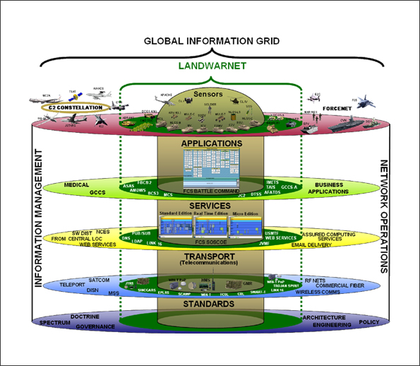
I-COP stacks multiple flows of information into a single picture // Source: ac.jp

Homeland Security News Wire - March 7, 2012

A U.S. Marine stationed at the Quantico base in Virginia has developed sophisticated mapping software that can give users full situational awareness of their surroundings in real-time.

The Installation Common Operational Picture (I-COP), developed by Marine specialist Michael Lisovich, is essentially a “super map,” taking in a torrent of data streams from emergency dispatch reports to weather forecasts, traffic reports, and security system alerts.

Pete Streng, Quantico’s director of operations, said the tool, which is accessible online, essentially provides users with up to the minute information on everything around the base, allowing officials to make fast, informed decisions.

InsideNovareports that Streng contacted Lisovich several years ago requesting a system that would give officials a better grasp of the base’s critical infrastructure system.

New Facebook Feature Lets You Mark Yourself as ‘Safe’ After Major Disaster

submitted by Samual Bendett

techland.time.com - by Keith Wagstaff - February 29, 2012

In the wake of a disaster, one of the most terrifying things is not knowing if your loved ones are safe. Contact can be difficult: Landlines can go down and cellphones can lose their charge. Even if you call your mother and tell her you’re safe, you still have a large network of friends and family that might still be worried about you.

That’s why Facebook’s new Disaster Message Board makes sense. Right now it’s only being tested in Japan, which is still dealing with the aftermath of the Fukushima disaster.

(READ COMPLETE ARTICLE)

Tornado Victims Flock to Facebook for Helping Hand


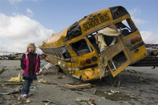
Student Madeline Evans walks past a destroyed school bus after a tornado devastated the town of Henryville, Indiana, March 3, 2012.  Credit: Reuters/Indiana National Guard/Sgt. John Crosby

by Mary Slosson - March 5, 2012

(Reuters) - Residents of the storm-ravaged communities in the Midwest are reaching out to each other, neighbor to neighbor, through social media sites to coordinate disaster relief and share information.

A chain of fast-moving tornadoes spawned by massive thunderstorms cut a swath of destruction from the Midwest to the Gulf of Mexico on Friday, killing at least 39 people and leaving many residents homeless and seeking food, clothing, and shelter.

With phone connections spotty as emergency workers tried to repair downed power lines and clear debris, Facebook pages -- accessible by cell phone, mobile device, or computer -- have proven a go-to source for communities to assist one another.

(READ COMPLETE ARTICLE)

Cell Phone App - American Red Cross: Shelter View


A free cell phone app download that provides emergency response information, and a list of all shelters currently open in the United States.

(CLICK HERE TO GO TO THE APP STORE)

Pages

howdy folks