User login
Language
Anonymous's groups in this site
User is not a member of any group.
Your groups across all your sites
User is not a member of any group.
Recent Content
Who's online
There are currently 0 users online.
You are here
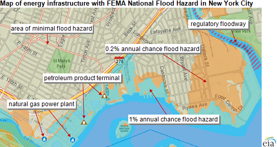
Energy Infrastructure - Flood Vulnerability Assessment Map
Sat, 2014-08-16 22:43 — Kathy Gilbeauxsubmitted by Sarah Slaughter
Source: U.S. Energy Information Administration
eia.gov - August 6, 2014
A new component of EIA's Energy Mapping System allows users to view critical energy infrastructure that may be vulnerable to coastal and inland flooding. These new map layers enable the public to see existing energy facilities that could potentially be affected by flooding caused by hurricanes, overflowing rivers, flash floods, and other wet-weather events.
The mapping tool combines flood hazard information from the Federal Emergency Management Agency (FEMA) with EIA's existing U.S. Energy Mapping System that shows power plants, oil refineries, crude oil rail terminals, and other critical energy infrastructure. The maps can help readers understand what energy infrastructure assets are currently exposed to flood risk.
(CLICK HERE - Energy Infrastructure with FEMA National Flood Hazard)
Recent Comments