User login
Language
Anonymous's groups in this site
User is not a member of any group.
Your groups across all your sites
User is not a member of any group.
Recent Content
Recent Comments
- Analysis: Long flu season winds down in the US --AP 3 days 6 hours ago
- USDA faulted for disclosing scant information about bird flu 1 week 2 days ago
- United Health advancec over $2 billion to hacking victims 1 month 2 weeks ago
- Charts show how flu, COVID and RSV have spread in the U.S. 1 month 2 weeks ago
Who's online
There is currently 1 user online.
- mike kraft
You are here
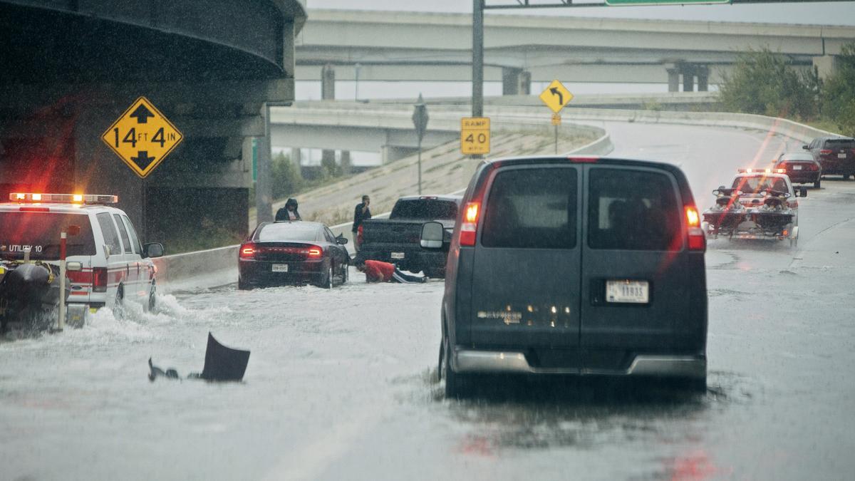
Stalled cars and rescue vehicles on a flooded section of Interstate 610 in Houston on Aug. 27. ALYSSA SCHUKAR
bizjournals.com - by Olivia Pulsinelli - July 6, 2018
The U.S. Army Corps of Engineers announced July 5 how it will allocate billions of dollars for more flood-mitigation efforts.
Of the allocations announced July 5, the largest portion is more than $13.9 billion for the construction of nearly 60 projects to reduce damage from floods and storms across multiple states and Puerto Rico.
(CLICK HERE - READ COMPLETE ARTICLE)
Orange County, Texas - see page 11 in the 75 page report within the link below. It describes the proposed construction for the levee in Orange County and includes a map showing the placement of the proposed levee.
Orange County, Texas - also see the maps on pages 5-11 and 6-2 in the 278 page report within the link below. The maps show alternate versions of the proposed levee construction.
CLICK HERE - National Levee Database - Levees of the Nation
CLICK HERE - US Army Corps of Engineers - National Levee Database


Comments
Flood Thy Neighbor: Who Stays Dry and Who Decides?
propublica.org - by Lisa Song, Patrick Michels, Al Shaw - August 6, 2018
. . . Levees have been the nation’s most common method of flood control for much of U.S. history, despite a major drawback: Levees protect the land immediately behind them, but can make flooding worse for people nearby by cutting off a river’s ability to spread over the floodplain — the flat, low-lying land beside the river channel. This is a basic matter of physics and something the Corps has known since at least 1852, when a report it commissioned demonstrated that as levees confine a river to a narrower channel, they force water to flow higher and faster. A levee such as the one at Valley Park, on just one side of the Meramec, creates a traffic-jam effect that forces water higher on the opposite bank and upstream.
(CLICK HERE - READ COMPLETE ARTICLE)
Re: Flood Thy Neighbor: Who Stays Dry and Who Decides?
When a levee is built to protect an area against storm surge, it will also be important to consider the effects of water attempting to flow downstream after a rain / flood event such as Hurricane Harvey . . . how will all that rain water behave when it encounters a levee blocking the downstream flow?
Texas General Land Office - Coastal Texas Study
LINKS TO SUPPORTING DOCUMENTATION . . .
CLICK HERE - U.S. Army Corps of Engineers - Planning and Environmental Documents for Public Review
CLICK HERE - Texas GLO - CMR. BUSH: COASTAL TEXAS STUDY PUBLIC COMMENT PERIOD EXTENDED DESPITE GOVERNMENT SHUTDOWN
CLICK HERE - UPDATE: U.S. Army Corps of Engineers releases study on Texas coastal barrier project
CLICK HERE - Coastal Texas Protection & Restoration Feasibility Study
CLICK HERE - Texas GLO - Coastal Texas Study