Weather - US

Primary tabs

This working group is focused on discussions about weather events.

The mission of this working group is to focus on discussions about weather events.

Members

Amanda Cole Kathy Gilbeaux mdmcdonald tkm

Email address for group

weather-us@m.resiliencesystem.org

Google Crisis Map - Superstorm Sandy

http://google.org/crisismap/2012-sandy

Sandy is a major storm, previously a hurricane, that has caused extensive flooding, power and transportation outages, and physical damage to the US East Coast and Caribbean. More than 100 deaths have been linked to the storm.

(GO TO THE SUPERSTORM SANDY GOOGLE CRISIS MAP)

Hurricane Sandy: Problems at Five Nuke Plants


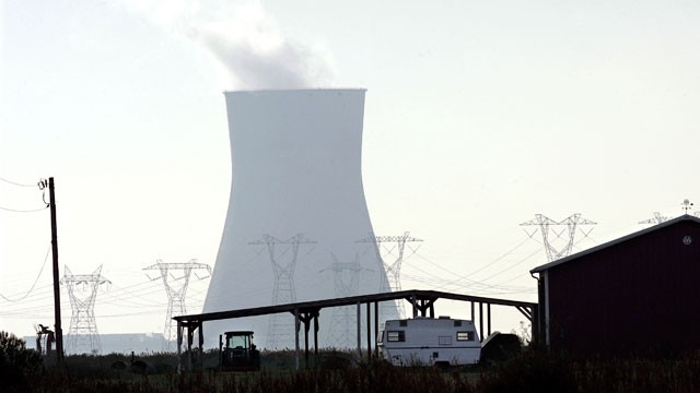
A cooling tower is seen at the Salem nuclear power plant known as Artificial Island. (Mel Evans/AP Photo)

ABC News - by Mark Schone - October 30, 2012

The nation's oldest nuclear plant declared an alert and a second plant just 40 miles from New York City was forced to shut down power as five different nuke plants in Hurricane Sandy's path experienced problems during the storm.

Indian Point in Buchanan, New York, on the Hudson River north of New York City, automatically shut power to its unit 3 on Monday night "as a result of an electrical grid disturbance," according to Entergy, the plant's operator.

The connection between the generator and the offsite grid was lost, and the unit is designed to shut down to protect itself from electrical damage.

(READ COMPLETE ARTICLE)

Global Warming Systemically Caused Hurricane Sandy


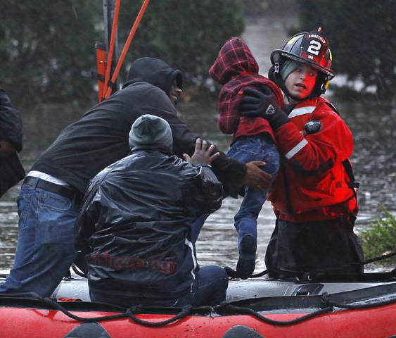
Residents in Little Ferry, N.J., were rescued from flood waters. (photo: Adam Hunger/Reuters)

huffingtonpost.com - by George Lakoff - October 30, 2012

Yes, global warming systemically caused Hurricane Sandy -- and the Midwest droughts and the fires in Colorado and Texas, as well as other extreme weather disasters around the world. Let's say it out loud, it was causation, systemic causation.

There is a difference between systemic and direct causation.

(READ COMPLETE ARTICLE - HUFFINGTON POST)

(IMAGE AND SAME ARTICLE - READER SUPPORTED NEWS)

(FEE AND DIVIDEND)

Resources - Hurricane Sandy

Resources - from Humanity Road - Links to Evacuation Maps and Information, Animal Resources, Utility/Power Outage websites, State Office websites, Transportation, Shelter, Emergency Management, Facebook Pages and much more . . .
http://www.humanityroad.org/Sandy.htm#.UIst7Z8CbT8.twitter

Google Crisis Map
http://google.org/crisismap/sandy-2012

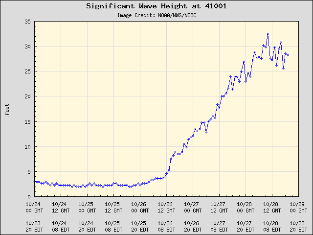
NDBC - Hurricane Sandy - 30 Foot Significant Wave Heights - National Data Buoy Center Station 41001


ndbc.noaa.gov - October 28, 2012

The National Data Buoy Center has recorded a Significant Wave Height (WVHT) of 30 feet.  This data was recorded at Buoy Station # 41001 - EAST HATTERAS - 150 NM East of Cape Hatteras.

Significant wave height (meters) is calculated as the average of the highest one-third of all of the wave heights during the 20-minute sampling period. See the Wave Measurements section.

Recording - Station 41001
http://www.ndbc.noaa.gov/show_plot.php?station=41001&meas=sght&uom=E&time_diff=-4&time_label=EDT

Information on Station 41001
http://www.ndbc.noaa.gov/station_history.php?station=41001

About Wave Measurements
http://www.ndbc.noaa.gov/measdes.shtml

Tropical Weather Outlook

Hurricane Isaac Tests Loyola University's Emergency Response Plans

submitted by Samuel Bendett

Homeland Security News Wire - September 11, 2012

In the days following Hurricane Isaac’s slow march across south Louisiana, Loyola University New Orleans administrators have been reviewing their response with a critical eye to ensure emergency preparations continue to evolve and meet the demands of each situation; beginning Tuesday, 28 August, New Orleans felt the first of Isaac’s high winds and heavy rains – but Loyola University was ready.

(READ COMPLETE ARTICLE)

Significant Wave Height - National Data Buoy Center - Buoy 42012 - Orange Beach, AL

                                               (CLICK ON IMAGES FOR ADDITIONAL INFORMATION)


Wave heights approaching 20 ft at NDBC Buoy 42012 - Orange Beach, AL Buoy located 117 miles east of Hurricane Isaac.

August 28, 2012 - 3:50 pm CDT

http://www.ndbc.noaa.gov/station_page.php?station=42012

https://www.facebook.com/pages/National-Data-Buoy-Center/128538033843673

Pages

howdy folks
Page loaded in 0.649 seconds.