You are here

Flood

Texas Flooding Overflows Oil Wells, Fracking Sites


Photo: El Paso Times - (CLICK HERE to view additional photos)

texashillcountry.com - by THC Staff - May 6, 2016

The recent Texas flooding has overwhelmed oil wells and fracking sites, overflowing crude oil and chemicals into rivers statewide.

With the onset of storms finally subsiding, state officials have begun to assess the entirety of the damage caused by the flooding that occurred across the state.

As KIII reported, “state emergency management officials have taken dozens of photographs that show sheens and plumes spreading from tipped tanks and flooded production sites” of the Sabine River flood on the Louisiana-Texas border.

(READ COMPLETE ARTICLE)

CLICK HERE - kiiitv.com - Flooding Flushes Oil, Chemicals into Texas Rivers


Country / Region Tags: 
Problem, Solution, SitRep, or ?: 

Over 20 Inches of Rain Triggers Historic Flash Flooding In Parts of the South


Sarah Yatcko, left, holds her son Tucker Neal as they are evacuated by boat with her father Jim Yatcko, by Bossier Parish Sheriff personnel during rising floodwaters in Bossier Parish, La., Thursday, March 10, 2016. (AP Photo/Gerald Herbert)

weather.com - by Quincy Vagell and Chris Dolce and Jon Erdman - March 10, 2016

Torrential rainfall continues to swamp parts of the South, smashing March records, and triggering major flash flooding and worsening river flooding in parts of Louisiana, Texas, Arkansas and Mississippi. Heavy rain has also spread into parts of western Tennessee, western Kentucky, and western Mississippi.

More than 20 inches of rain had fallen near Monroe, Louisiana, by Thursday morning, prompting numerous rescues. The official airport reporting station in Monroe had picked up 18.96 inches of rain in less than two days by 12 p.m. CST Thursday. This is closing in on the record wettest month for that location set in October 2009 when 20.56 inches was recorded.

Major flooding has also swamped the Shreveport, Louisiana, area where up to 16 inches of rain has fallen. Elsewhere, double-digit rainfall totals have been recorded in east Texas, southern Arkansas, and northwest Mississippi.

Country / Region Tags: 
General Topic Tags: 
Problem, Solution, SitRep, or ?: 

Midwest Flooding - Slow Motion Disaster


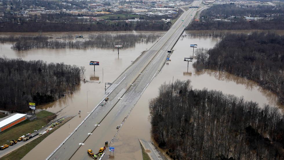
In this aerial photo, floodwater covers Interstate 55, Thursday, Dec. 31, 2015, in Arnold, Mo.  Surging Midwestern rivers forced hundreds of evacuations, threatened dozens of levees and brought transportation by car, boat or train to a virtual standstill Thursday in the St. Louis area.  (AP Photo/Jeff Roberson)

Dozens of counties in Missouri, Arkansas and Illinois declared disaster areas

Evacuations around St Louis as river levels set to rise again on Thursday

Floods swamp Missouri, Illinois; nine million people in risk areas

reuters.com - by Mary Wisniewski - December 31, 2015

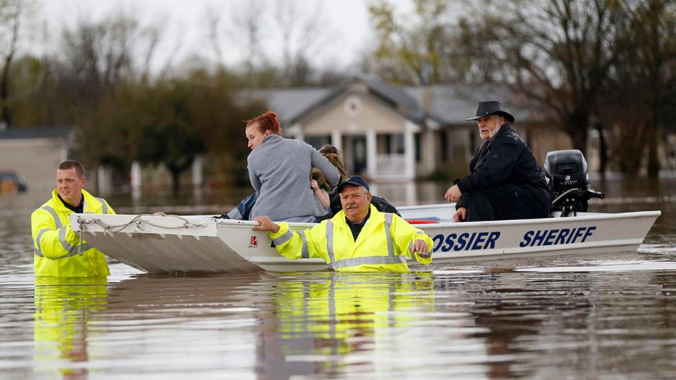
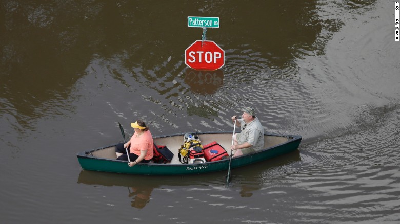
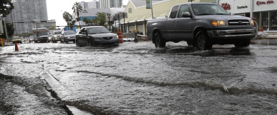
Record flooding from rain-swollen rivers has washed out hundreds of structures in Missouri, Illinois, Arkansas and eastern Oklahoma, forcing thousands to flee their homes, and 9.3 million Americans still face flood warnings.

At least 28 people have died in the U.S. Midwest's extreme weather since the weekend, mostly from driving into flooded areas after storms dropped up to 12 inches (30 cm) of rain, officials said.

The days of downpours have pushed the mighty Mississippi and its tributaries to record highs or levels not seen in decades, the National Weather Service and local officials said.

Country / Region Tags: 
General Topic Tags: 
Problem, Solution, SitRep, or ?: 

New Orleans Area's Upgraded Levees Not Enough for Next 'Katrina,' Engineers Say


The Lake Borgne Surge Barrier, which rises 26 feet above sea level, is designed to be overtopped by storm surges created by a hurricane with a 1 percent chance of occurring in any year, the so-called 100-year storm, hits the area. The overtopping water will be stored in the Gulf Intracoastal Waterway and the Industrial Canal in New Orleans. Larger storms will cause even more water to overtop the wall.

nola.com - by Mark Schleifstein - August 18, 2015

The rebuilt New Orleans area hurricane levee system remains inadequate to protect the heart of the nation's 45th largest metropolitan area from another Hurricane Katrina or larger storm, nationally-known engineers and scientists said almost a decade after the 2005 storm.

Country / Region Tags: 
Problem, Solution, SitRep, or ?: 

Texas - Catastrophic and Historic Flooding

                            Wimberley, Texas                                                    San Marcos, Texas


                          Austin, Texas                                                                Houston, Texas


AN EXPANDING LIST OF FLOOD-RELATED INFORMATION AND ASSISTANCE RESOURCES (CLICK ON THE LINKS BELOW)

CLICK HERE -President Declares Disaster for Texas

CLICK HERE - Federal Aid Programs for State of Texas Declaration

CLICK HERE - Texas Department of Public Safety - Emergency Management - Situation Reports

Country / Region Tags: 
Problem, Solution, SitRep, or ?: 

'Possibly Catastrophic': Texas Braces for Even More Flooding


People canoe through floodwaters in Houston on Saturday, May 30.  Torrential rains have given Texas the wettest month on record, according to Texas A&M climatologists.  In all, 37.3 trillion gallons of water have fallen over the state in May, the National Weather Service said.

cnn.com - by Kevin Conlon - June 14, 2015

(CNN) For portions of rain-battered Texas, the warnings issued by the National Weather Service on Sunday must have seemed like a cruel joke: a tropical storm that is potentially forming in the Gulf of Mexico is headed straight for them.

"Through Wednesday, widespread rainfall totals could easily average 6 to 8 inches with some amounts exceeding 10 inches," read the ominous forecast issued by the weather service office in Houston. "This will obviously lead to a dangerous flood situation."

Local officials sounded even more alarmed, calling the event "possibly catastrophic."

(READ COMPLETE ARTICLE)

Country / Region Tags: 
Problem, Solution, SitRep, or ?: 

Flood and Drought Risk to Cities on Rise Even with No Climate Change

sciencedaily.com - March 5, 2015

Source:  Texas A&M University

CLICK HERE - STUDY - Changing global patterns of urban exposure to flood and drought hazards

Summary:  A heads-up to New York, Baltimore, Houston and Miami: a new study suggests that these metropolitan areas and others will increase their exposure to floods even in the absence of climate change.  Their work is published in Global Environmental Change. . . .

. . . "Through land change, bank protection, channelization, and other means, urbanization can also alter the geomorphology of river channels and floodplains, which in turn may contribute to increased risk of flooding."

"Our findings suggest that future urban expansion in flood and drought prone zones will at least be as important as population growth and economic development in increasing their exposure," the researchers add.

"With climatic changes, this exposure is only expected to increase in the future. Thus, proper planning and financing in fast growing cities today will be critical in mitigating future losses due to floods and droughts."

(READ COMPLETE ARTICLE)


Country / Region Tags: 
Problem, Solution, SitRep, or ?: 

Miami Beach Prepares For Annual 'King Tide' Flooding And A Taste Of Future Sea Level Rise

Vehicles negotiate heavily flooded streets as rain falls, Tuesday, Sept. 23, 2014, in Miami Beach, Fla. Certain neighborhoods regularly experience flooding during heavy rains and extreme high tides. New storm water pumps are currently being installed along the bay front in Miami Beach. National and regional climate change risk assessments have used the flooding to illustrate the Miami area's vulnerability to rising sea levels. ASSOCIATED PRESS

Image: Vehicles negotiate heavily flooded streets as rain falls, Tuesday, Sept. 23, 2014, in Miami Beach, Fla. Certain neighborhoods regularly experience flooding during heavy rains and extreme high tides. New storm water pumps are currently being installed along the bay front in Miami Beach. National and regional climate change risk assessments have used the flooding to illustrate the Miami area's vulnerability to rising sea levels. ASSOCIATED PRESS

huffingtonpost.com - October 3rd, 2014 - Zachary Fagenson and David Adams

Country / Region Tags: 
Problem, Solution, SitRep, or ?: 

Energy Infrastructure - Flood Vulnerability Assessment Map

submitted by Sarah Slaughter   


Source: U.S. Energy Information Administration

eia.gov - August 6, 2014

A new component of EIA's Energy Mapping System allows users to view critical energy infrastructure that may be vulnerable to coastal and inland flooding. These new map layers enable the public to see existing energy facilities that could potentially be affected by flooding caused by hurricanes, overflowing rivers, flash floods, and other wet-weather events.

The mapping tool combines flood hazard information from the Federal Emergency Management Agency (FEMA) with EIA's existing U.S. Energy Mapping System that shows power plants, oil refineries, crude oil rail terminals, and other critical energy infrastructure. The maps can help readers understand what energy infrastructure assets are currently exposed to flood risk.

(READ COMPLETE ARTICLE)

(CLICK HERE - Energy Infrastructure with FEMA National Flood Hazard)

Country / Region Tags: 
General Topic Tags: 
Problem, Solution, SitRep, or ?: 

Pages

Subscribe to Flood
howdy folks