You are here

Flood

Miami, the Great World City, is Drowning While the Powers that Be Look Away

submitted by Albert Gomez 


In November 2013, a full moon and high tides led to flooding in parts of the city, including here at Alton Road and 10th Street. Photograph: Corbis

Low-lying south Florida, at the front line of climate change in the US, will be swallowed as sea levels rise. Astonishingly, the population is growing, house prices are rising and building goes on. The problem is the city is run by climate change deniers

theguardian.com - by Robin McKie - July 11, 2014

A drive through the sticky Florida heat into Alton Road in Miami Beach can be an unexpectedly awkward business. Most of the boulevard, which runs north through the heart of the resort's most opulent palm-fringed real estate, has been reduced to a single lane that is hemmed in by bollards, road-closed signs, diggers, trucks, workmen, stacks of giant concrete cylinders and mounds of grey, foul-smelling earth.

Country / Region Tags: 
Problem, Solution, SitRep, or ?: 

Life-Threatening Flooding Submerges Pensacola, Florida


Photo - @TWCBreaking

nbcnews.com - By Alastair Jamieson and M. Alex Johnson - April 30, 2014

Torrential rainfall and “life-threatening" flooding turned deadly in Florida’s panhandle late Tuesday - the latest fallout from a monster weather system that has killed at least 35 people in six states. . .

. . . More than two feet of rain fell in a 26-hour period in Pensacola, Fla. according to one rain gauge, washing away bridges and closing mile after mile of highways across the region, leaving hundreds of drivers stranded for hours. . .

. . . More than five inches fell on Pensacola in the single hour between 9 p.m. and 10 p.m. CT (10 p.m. and 11 p.m. ET) Tuesday, the NWS said.

(READ COMPLETE ARTICLE)

Country / Region Tags: 
Problem, Solution, SitRep, or ?: 

Sea, Lake, and Overland Surges from Hurricanes (SLOSH)

nhc.noaa.gov

SLOSH Model - Introduction

The Sea, Lake and Overland Surges from Hurricanes (SLOSH) model is a computerized numerical model developed by the National Weather Service (NWS) to estimate storm surge heights resulting from historical, hypothetical, or predicted hurricanes by taking into account the atmospheric pressure, size, forward speed, and track data. These parameters are used to create a model of the wind field which drives the storm surge.

The SLOSH model consists of a set of physics equations which are applied to a specific locale's shoreline, incorporating the unique bay and river configurations, water depths, bridges, roads, levees and other physical features.

(READ COMPLETE ARTICLE)

Country / Region Tags: 
Problem, Solution, SitRep, or ?: 

Key Senate Vote on Flood Insurance Rate Delay Pushed to Next Week

insurancejournal.com - by Andrew G. Simpson - January 7, 2014

The U.S. Senate is expected to take a key vote soon on a bill that would delay some of the flood insurance rate hikes triggered by the Biggert-Waters Flood Insurance Reform Act of 2012. . .

. . . The procedural vote on S.1846 was originally planned for Wednesday, but the Senate is still dealing with an extension of federal unemployment benefits, delaying consideration of the flood bill. U.S. Sen. Mary Landrieu (D-La.), a major advocate for the bill, told USA Today that  “next week is more realistic” for any vote on the flood bill.

(READ COMPLETE ARTICLE)

Country / Region Tags: 
General Topic Tags: 
Problem, Solution, SitRep, or ?: 

Fed Flood Maps Left NY Unprepared for Sandy — and FEMA Knew It

Flooding in Red Hook, Brooklyn after Sandy (Flickr/gunnicool)

The agency ignored state and city officials' appeals to update the maps with better data until it was too late.

wnyc.org - December 6, 2013
by Al Shaw : ProPublica / Theodoric Meyer : ProPublica / Christie Thompson : ProPublica

When Patrice and Philip Morgan bought a house near the ocean in Brooklyn, they were not particularly worried about the threat of flooding.

Federal maps showed their home was outside the area at a high risk of flood damage. . .

. . . But the maps drawn up by the Federal Emergency Management Agency were wrong. And government officials knew it.

(READ COMPLETE ARTICLE)

Country / Region Tags: 
Problem, Solution, SitRep, or ?: 

WEATHER ADVISORY -URGENT

Tue Nov 26 15:57:54 2013 
STATUS: Open - Active 
PROGNOSIS: Monitoring 
Weather-Nor-Easter 
Citywide  


(OEM WEATHER DISTRIBUTION LIST)

URGENT - WEATHER MESSAGE 
NATIONAL WEATHER SERVICE NEW YORK NY 
345 PM EST TUE NOV 26 2013

...STRONG WINDS EXPECTED FROM LATE TONIGHT INTO WEDNESDAY MAINLY 
IN AND NEAR NEW YORK CITY AND COASTAL SECTIONS OF SOUTHEAST NEW 
YORK AND CONNECTICUT...

NORTHERN MIDDLESEX-SOUTHERN FAIRFIELD-SOUTHERN NEW HAVEN-HUDSON- 
SOUTHERN WESTCHESTER-NEW YORK (MANHATTAN)-BRONX- 
RICHMOND (STATEN ISLAND)-KINGS (BROOKLYN)-NORTHERN QUEENS- 
SOUTHERN QUEENS- 
345 PM EST TUE NOV 26 2013

...WIND ADVISORY NOW IN EFFECT FROM MIDNIGHT TONIGHT TO 9 AM EST 
WEDNESDAY...

* LOCATIONS...NEW YORK CITY...HUDSON COUNTY...SOUTHERN 
  WESTCHESTER COUNTY... COASTAL SOUTHEASTERN CONNECTICUT...AND 
  NORTHERN MIDDLESEX COUNTY.

* HAZARDS...STRONG WINDS.

* WINDS...SOUTHEAST 15 TO 25 MPH WITH GUSTS UP TO 50 MPH.

* TIMING...STRONGEST WINDS WILL BE FROM LATE TONIGHT INTO EARLY 
  WEDNESDAY MORNING.

* IMPACTS...POTENTIAL FOR DOWNED TREE LIMBS AND POWER LINES...AND 
  POSSIBLY A FEW TREES...CAUSING PROPERTY DAMAGE AND POWER 
  OUTAGES.

PRECAUTIONARY/PREPAREDNESS ACTIONS...

Country / Region Tags: 
Problem, Solution, SitRep, or ?: 

The Hard Math of Flood Insurance in a Warming World


A man walks through flooded streets in Hoboken, New Jersey, after Superstorm Sandy | Emile Wamsteker/Bloomberg via Getty Images

As subsidized rates of federal flood insurance rise, property owners along the coasts get angry. But we need insurance that reflects the risks of a changing planet

time.com - by Bryan Walsh - October 1, 2013

Thousands of homeowners in flood-prone parts of the country are going to be in for a rude awakening.  On Oct. 1, new changes to the National Flood Insurance Program (NFIP), which offers government-subsidized policies for households and businesses threatened by floods, mean that businesses in flood zones and homes that have been severely or repeatedly flooded will start going up 25% a year until rates reach levels that would reflect the actual risk from flooding. (Higher rates for second or vacation homes went into effect at the start of 2013.) That means that property owners in flood-prone areas who might have once been paying around $500 a year—rates that were well below what the market would charge, given the threat from flooding—will go up by thousands of dollars over the next decade.

Country / Region Tags: 
Problem, Solution, SitRep, or ?: 

Boulder Flood Relief

                                                   CLICK HERE - BOULDER FLOOD RELIEF


Boulder Flood Relief is a local, boots on the ground, all-volunteer group organizing relief for displaced and in need individuals.

Call: (720) 943-4482

http://boulderfloodrelief.org/

Country / Region Tags: 
Problem, Solution, SitRep, or ?: 

E. Coli, Oil Spills and Airlifts: Fallout from Colorado Flooding Continues

cnn.com - by Greg Botelho and Elwyn Lopez - September 20, 2013

(CNN) -- Efforts continued Friday to cope with fallout from flooding that''s rocked the Rocky Mountain state -- including more airlifts of stranded residents, discoveries of oil spills and a plea to one town's residents to stay away until E. coli is cleared from their tap water.

Country / Region Tags: 
Problem, Solution, SitRep, or ?: 

Colorado Flooding: Did Climate Change Play A Role In Recent Disaster?

Local residents look at the damage along Topaz Street September 13, 2013 in Boulder, Colorado. (Photo by Marc Piscotty/Getty Images) 
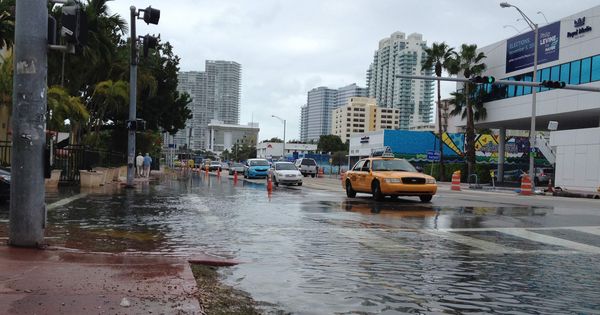
Image: Local residents look at the damage along Topaz Street September 13, 2013 in Boulder, Colorado. (Photo by Marc Piscotty/Getty Images)

huffingtonpost.com - September 14th, 2013

The Boulder, Colo. area is reeling after being inundated by record rainfall, with more than half a year’s worth of rain falling over the past three days. During those three days, 24-hour rainfall totals of between 8 and 10 inches across much of the Boulder area were enough to qualify this storm as a 1 in 1,000 year event, meaning that it has a 0.1 percent chance of occurring in a given year.

At least four people have been confirmed dead so far, and thousands have been evacuated from their homes and businesses.

(VIEW COMPLETE ARTICLE)

Country / Region Tags: 
General Topic Tags: 
Problem, Solution, SitRep, or ?: 

Pages

Subscribe to Flood
howdy folks