You are here

Map

NASA Map of Earth's Seasons Over 20 Years Highlights Climate Change

The visualization shows spring coming earlier and the Arctic ice caps receding over time

NASA - theguardian.com - AP - November 17, 2017

Nasa has captured 20 years of changing seasons in a striking new global map of planet Earth​.

The data visualization, released this week, shows Earth’s fluctuations as seen from space.

(READ COMPLETE ARTICLE)

CLICK HERE - NASA - The Living Planet - The Changing Colors of our Living Planet

CLICK HERE - NASA - Our Living Planet from Space

Country / Region Tags: 
Problem, Solution, SitRep, or ?: 

Tropical Storm Jose - Tropical-Storm-Force Winds Probability

Current predicted probability of tropical-storm-force winds from Tropical Storm Jose.

Image: Current predicted probability of tropical-storm-force winds from Tropical Storm Jose.

nhc.noaa.gov - September 15th 2017

Note: The time of the tropical cyclone's center location at the bottom of the graphic will be 3 hours earlier than the time of the current advisory. The forecast cycle for each advisory begins 3 hours prior to the issuance of the advisory products.

(VIEW COMPLETE WEBPAGE)

Problem, Solution, SitRep, or ?: 

Facebook Disaster Maps - Using Data to Help Communities Recover and Rebuild

newsroom.fb.com - By Molly Jackman - June 7, 2017

Today, we are introducing disaster maps that use aggregated, de-identified Facebook data to help organizations address the critical gap in information they often face when responding to natural disasters. Many of these organizations worked with us to identify what data would be most helpful and how it could be put to action in the moments following a disaster.

This initiative is the product of close work with UNICEF, the International Federation of the Red Cross and Red Crescent Societies, the World Food Programme, and other organizations. 

(READ COMPLETE ARTICLE)

ALSO SEE RELATED ARTICLE HERE - Surveillance for good? Facebook tracks disaster victims

CLICK HERE - Mark Zuckerberg - Facebook

Country / Region Tags: 
Problem, Solution, SitRep, or ?: 

Map Shows How Paris Reversal Isolates U.S. From World


1Nicaragua refused to join the Paris Agreement because the country believes that the accord’s voluntary goals are insufficient.

2A brutal civil war and international sanctions made it difficult for Syria to attend the Paris negotiations and deliver an emissions-reduction goal.

Country / Region Tags: 
General Topic Tags: 
Problem, Solution, SitRep, or ?: 

What Happens If a Nuclear Bomb Goes Off in Manhattan?

Manhatten skyline. Lucas Jackson / Reuters

Image: Manhatten skyline. Lucas Jackson / Reuters

theatlantic.com - March 15th 2017 - Kaveh Waddell

On a quiet afternoon, two medium-sized nuclear blasts level portions of Manhattan.

If this were a movie, hordes of panicked New Yorkers would pour out into the streets, running around and calling out for their loved ones. But reality doesn’t usually line up with Hollywood’s vision of a disaster scene, says William Kennedy, a professor in the Center for Social Complexity at George Mason University. 

(VIEW COMPLETE ARTICLE)

Country / Region Tags: 
Problem, Solution, SitRep, or ?: 

Maps - Pipelines - Trains that Carry Crude Oil

This map shows the incidents pipeline operators have reported to the Pipeline and Hazardous Materials Safety Administration, known as PHMSA, since 2010.
(Click on the link below, and scroll down)
http://insideenergy.org/2016/11/18/protesters-say-pipelines-are-dangerous-are-they/

The PHMSA makes searchable information about where pipelines are in the U.S., broken down by county, available at its website.
(Click on the link below)
https://pvnpms.phmsa.dot.gov/PublicViewer/

National Pipeline Mapping System
https://www.npms.phmsa.dot.gov

U.S. Department of Transportation - Pipeline and Hazardous Materials Safety Administration - Incident Statistics
http://www.phmsa.dot.gov/hazmat/library/data-stats/incidents

ProPublica - Crude Connections: Where Do Trains Carry Crude Oil?
http://projects.propublica.org/graphics/oil-trains


Country / Region Tags: 
General Topic Tags: 
Problem, Solution, SitRep, or ?: 

How Likely Are You To Deal With A Zika Outbreak? Check This Map

huffingtonpost.com - August 15th 2016 - Anna Almendrala

Now that Zika virus is spreading locally in Florida, U.S. residents, and especially pregnant women, are growing alarmed at the risk that they may face in their own communities. 

A new map estimating the risk of local Zika spread around the globe shows a relatively small likelihood that most of North America and Northern Asia will be affected. By contrast, all the variables are in place for local spread in most of Africa, South and Southeast Asia. 

(VIEW COMPLETE ARTICLE)

Country / Region Tags: 
Problem, Solution, SitRep, or ?: 

NASA Finds New Way to Track Ocean Currents from Space

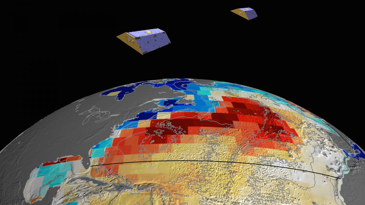
NASA's GRACE satellites (artist's concept) measured Atlantic Ocean bottom pressure as an indicator of deep ocean current speed. In 2009, this pattern of above-average (blue) and below-average (red) seafloor pressure revealed a temporary slowing of the deep currents. Image credit: NASA/JPL-Caltech

Image: NASA's GRACE satellites (artist's concept) measured Atlantic Ocean bottom pressure as an indicator of deep ocean current speed. In 2009, this pattern of above-average (blue) and below-average (red) seafloor pressure revealed a temporary slowing of the deep currents. Image credit: NASA/JPL-Caltech

jpl.nasa.gov - November 2nd, 2015

A team of NASA and university scientists has developed a new way to use satellite measurements to track changes in Atlantic Ocean currents, which are a driving force in global climate. The finding opens a path to better monitoring and understanding of how ocean circulation is changing and what the changes may mean for future climate.

(VIEW COMPLETE ARTICLE)

Country / Region Tags: 
General Topic Tags: 
Problem, Solution, SitRep, or ?: 

Google Street View cars are starting to map air pollution

Video: Video explaining the Aclima/Google Map partnership

theverge.com - July 29th, 2015 - Jacob Kastrenakes

A small number of Google Street View cars are recording more than photos of the road — they're also taking snapshots of the air quality around them. Aclima, a company that creates networks of environmental sensors, announced this week that it's been working with Google to put air quality detectors on some of its cars. The sensors allow Google's vehicles to pick up information on carbon dioxide, methane, black carbon, particulate matter, and other pollutants on a block-by-block basis.

(VIEW COMPLETE ARTICLE)

Country / Region Tags: 
General Topic Tags: 
Problem, Solution, SitRep, or ?: 

CDC - Mapping for Ebola: A Collaborative Effort


cdc.gov - January 14, 2015

One of the difficulties faced by teams responding to the current Ebola outbreak in West Africa is identifying individuals and communities residing in remote areas. Existing maps of these regions either do not exist or are inadequate or outdated. This means that basic data like location of houses, buildings, villages, and roads are not easily accessible, and case finding and contact tracing can be extremely difficult.

To help aid the outbreak response effort, volunteers from around the world are using an open-source online mapping platform called OpenStreetMap (OSM) to create detailed maps and map data of Guinea, Sierra Leone, Liberia, and parts of Mali.

(READ COMPLETE ARTICLE)

Country / Region Tags: 
Problem, Solution, SitRep, or ?: 

Pages

Subscribe to Map
howdy folks